

3 of Norways Best Hikes
- Aug 21, 2018
- 4 min read
During the month of June, I met up with my sister in Norway for a two-week road trip. Our main focus was to tick some of the iconic hikes off our bucket list. I still can't believe how lucky we were with the weather during our stay, blue skies and sunshine every day!
For most of these hikes the best time of year is mid-June to August. We were there slightly early in the beginning of June, but I think this was in our favour as we seemed to have beat the summer rush.
Trolltunga:
For Trolltunga we stayed in an AirBnB just 10 min outside of Odda, so that we could get an early start the next morning. In all honestly, my sister and I probably didn't do enough research about this hike far enough in advance. Usually the hike is only open from the 15th June, (our plan was to do it on the 5th), but luckily due to the great weather enough snow had melted! They have a Facebook page that has regular updates, which we found very helpful in the upcoming days before the hike.
The drive to the parking lot is pretty simple (parking is 500NOK for the day), there is also a shuttle that runs from Odda during peak season (250NOK). I would recommend parking if you can, so that you can leave easily once you are down and don't need to hand around for the bus. The total distance to 'Trolltunga' is 14km, making it a 28km roundtrip.
The first four km are straight up a winding road ... followed by another 3km of mostly up! It would appear that the Norwegians quite like hills! The path is well marked and easy to follow. As we neared the first main peak, we hit our first snow, which was still compact enough to walk up. The walk then evens out a bit and the views are incredible! I will just let the pictures speak for themselves!
When we reached the end, luckily as it was the start of the season there weren't hundreds of people! However, everyone is super friendly and there is a unofficial line for photographs. During peak season you may need to considering adding 1-2 hours to the hike time to allow for photos at the top and to admire the views!
It took us about 8 hours in total to complete the 28km, including stopping for photos along the way! I would definitely recommend that you take a lot of water (although you can full up along the way), as well as plenty of food, and warm clothes. Although the sun was shining, it was still a bit cold at the top with the wind. Sun tan lotion is a MUST, I had/have a terrible hiking boot tan now after not putting enough on! We also passed several people (mostly locals) who stayed the night at the top - definitely on my to do list!


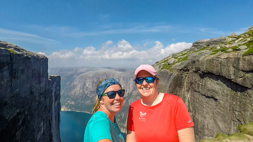
Kjeragbolten
Kjeragbolten is situated at the end of the Lysefjord, about 2 ½ hour’s drive from Stavanger. The drive is pretty easy going with great views, however the last 25km consists of a very narrow and winding mountain pass! It starts at Øygardstøl where you can park
for 200 NOK per car. There is also bathrooms and a restaurant for afterwards!
The hike is 10km (there and back) and is definitely the more challenging of the three. We managed to do it in just under 4 hours. It makes its way over three peaks before you reach the amazing view down the fjord and of course the boulder. Our fitness was put to the test with the straight up climbs of the rock faces with just chains to assist! I think we both agreed it would not be very pleasant in the pouring rain!
We started this hike slightly later due to the longer commute and shorter distance but there were still quite a few people already on the mountain. Similar to Trolltunga there is an unofficial line for photo’s on the boulder. Getting onto the boulder isn’t as bad as it seems, I feel like getting back was actually more terrifying. There was quite a lot of snow at the edge and on the path down to the boulder so getting close for better photo’s proved quite difficult.
Once we had had some food and were satisfied with our photo’s, we explored around there area as just west from the boulder is a ‘preikestolen’ look out point that you can walk to, however to the right of the boulder if an amazing look out point with breath-taking views down the fjord.
The way back took a bit quicker, however is pretty hard on your knees with the steep downhill, momentum is definitely your friend!


Preikestolen – Pulpit Rock
This is probably one of the easiest and most popular hikes in Norway. Similarly, to Kjeragbolten it is situated along the Lysefjord, closer to Stavanger. There are several ways of getting there, either by driving yourself (includes a ferry) or by ferry and bus from Stavanger. There is plenty of parking at the start for 200NOK. There is also bathrooms and a shop for an ice-cold coke when you get to the bottom.
The hike is about 7.5km long (return) and is the easiest of the three we did. As this is the most popular hike, there were an incredible amount of people on the path, making it less enjoyable than the others. Most of the hike is pretty easy walking, except for one climb of stairs that feels like it may never end. Like I said … the Norwegians really like their climbs!
When we reached to pulpit rock there were tons of people everywhere, so we took a few pictures along the edge before climbing a bit higher for a better view and less people! We didn’t really take as many pictures as it was impossible to get any without someone photo-booming you at some point! We ended up pacing it back due to the amount of people on the mountains as crowded paths just aren’t our favourite form of hiking.
I have seen a few Instagram posts of people who hike up and spend the night on pulpit rock, so by sunset they have the place to themselves…seems like the best idea to me!
Surprisingly we weren’t too stiff after any of these hikes, so we were able to enjoy them and spend some time exploring the cities as well.


Comments